Itoigawa-Shizuoka Tectonic Line and the Salt Trail
Transporting salt and maritime produce, the Salt Trail was a lifeline for people of inland Japan.
A. Start: Itoigawa Station
15 min. by car8 min. by rail + 10 min. walk
B. Ono Primary School and Arafune District
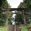
Follow the guideposts to visit Juōdō, Rokujizo, and the Bato Kannon Buddha statues. Continue through the village past Ono Shrine and its traditional stone lanterns. Near the shrine is a stone which was carved into a guidepost for the Salt Trail. It reads "Right for the drinking well, Left for Shinshuu (Nagano)"
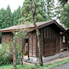
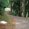
Kami Ono and Tea House Remains
The old road used to have a large number of tea houses, inns, taverns, and other places for travelers to rest before continuing along their way. At inns like this reconstructed one, porters would share rumors and information about the safety of the road ahead.
C. Historical Landmark—The Ono Utou
Stop by the small shrine where the Kanpa Jizo statue is enshrined on your way to the Ono Utou. Utou is a local word for these U-shaped roads that were carved through hills during the construction of the Salt Trail. They were created as the result of years of excavation, natural processes, and the trampling underfoot.

D. Nakayama Pass to Nechi and Niodo
The people who created the Salt Trail were clever in its design. It largely cuts through a ridge along the Himekawa River, specifically avoiding areas prone to landslides.
Rural Park and Pillow Lava
Along the right bank of the Nechi River is a wall of exposed pillow lava. Pillow lava is formed when underwater volcanoes erupt, sending out tube-shaped fingers of lava which cool and pile on top of each other, making pillow-like shapes. The green stone visible between the "pillows" is jasper. The jasper formed when hot water rich with silicic acid filled the cracks between the lava pillows.

Fossa Magna Park’s Massive Pillow Lava
The large, radially-shaped pillow lava in Fossa Magna Park is, at 12m in diameter, the largest in Japan. It's designated as a Municipal Natural Monument.
E. Fossa Magna Park Exposed Fault
Here you can inspect an exposed portion of the Itoigawa-Shizuoka Tectonic Line. The rock on the right side of the fault is andesite formed about 16 million years while the slightly dark green rock on the left is metagabbro, formed 260 million years ago. The reason they differ in age is because they are on two different continental plates. This tectonic line actually splits Japan in two.